Geocolor image in the eye of hurricane (Hurricane Lee not pictured) – Courtesy: Shutterstock – Image by Trong Nguyen
Hurricane Lee doubled its wind speeds in just one day, increasing its intensity on Thursday, then slammed into the west on Friday morning with 155 mph winds.
The Category 4 storm, however, appeared to have peaked during its overnight ascent at 165 mph hundreds of miles from land. Its winds decreased to 155 mph by Friday morning, but the storm was still quite strong and took advantage of the warm, wide water and little breezes.
Many people were eagerly anticipating what the severe storm would do in the next few days.
According to the five-day forecast from the National Hurricane Center, Lee will continue to move west-northwestward on a path that would take it somewhere northeast of the Turks and Caicos Islands and the eastern Bahamas on Tuesday, according to Michael Brennan, the director of the National Hurricane Center.
By Friday, life-threatening rip currents and high surf are predicted to reach around the northeastern Caribbean islands, where they will stay through the weekend.
The majority of the hurricane center’s computer models concur that Lee will move to the north, sparing Florida from a potential hurricane landfall.
“There’s absolutely no indication in front of us that this is going to be a huge threat to Florida, other than it’s going to be a huge rip current risk,” Jamie Rhome, the center’s deputy director, told USA TODAY on Friday.
“Right now, save the rip current risk, which is extreme, there’s no reason for people on the East Coast to be fearful,” Rhome said. “We need them to be informed and aware and check back for details but right now there’s no reason other than rip currents for people to be fearful.”
Starting as early as Sunday evening, rough surf, rip currents, and dangerous conditions are predicted along much of the US East Coast. The U.S. East Coast will experience a huge field of very large waves by Tuesday and Wednesday, “producing dangerous surf, rip current conditions, and undoubtedly some beach erosion,” according to Brennan.
The center has stated that there are still significant margins of error in estimates for direct impacts farther to the north, along the Northeast coasts of the United States or Canada.
“Right now, every computer model is showing there’s a big dip in the jet stream over the United States that seems very likely,” said David Nolan, a professor of atmospheric science at the University of Miami’s Rosenstiel School and its Cooperative Institute for Marine and Atmospheric Studies. “If that depiction comes through, what’s going to happen is Lee’s going to basically be pulled up.”
However, it’s still too early to say with certainty what effects the U.S. East Coast and Canada would experience by late next week, according to Nolan, who echoed advice from the hurricane center’s forecast discussions.
According to the National Hurricane Center, Lee was 565 miles east of the northern Leeward Islands at 11 a.m. on Friday and was moving 13 mph to the west-northwest. Brennan stated that Lee has already started to slow down and will eventually slow to 6-7 mph.
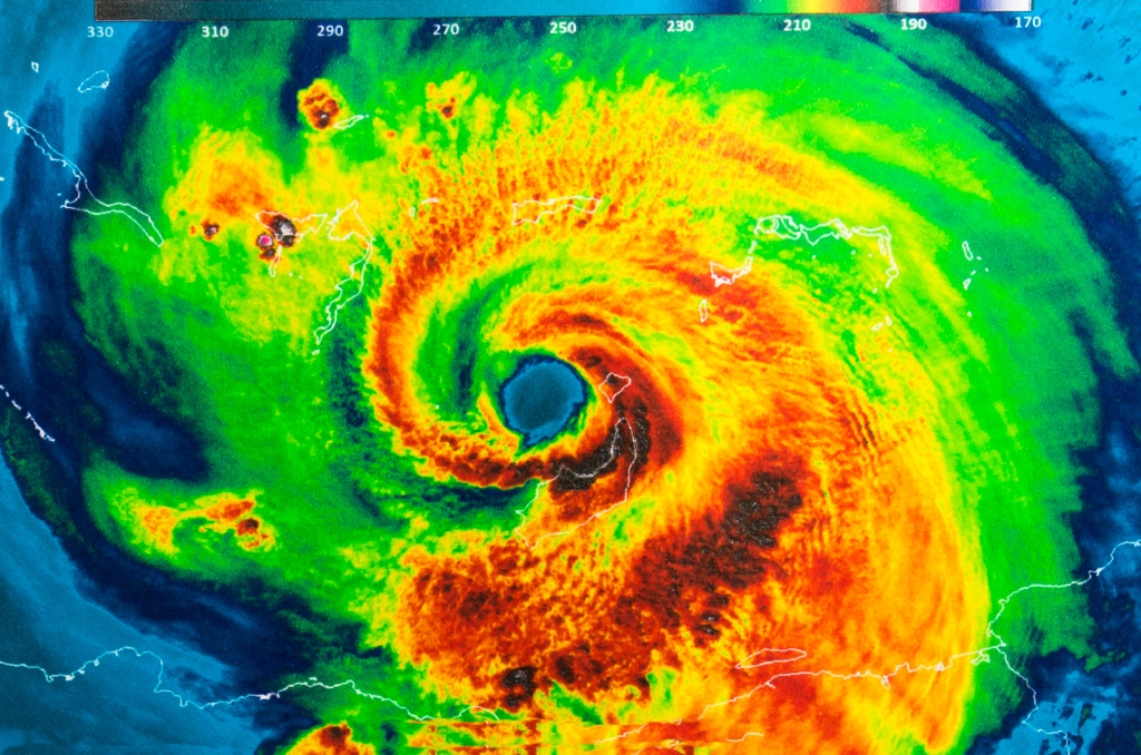
A traditional major hurricane was seen in satellite photographs, with a distinct eye, and its core pressure has already started to increase, from 926 millibars to 942 millibars.
A 35-mile radius around the storm’s core saw hurricane-force winds, while a 140-mile radius saw tropical-storm-force winds.
According to Brennan, the greatest waves might be twice as high because the top third of wave heights have been averaging 45 to 50 feet close to the storm’s center.
Stories that matter are our priority. At Florida Insider, we make sure that the information we provide our readers is accurate, easy-to-read, and informative. Whether you are interested in business, education, government, history, sports, real estate, nature or travel: we have something for everyone. Follow along for the best stories in the Sunshine State.
Melissa’s career in writing started more than 20 years ago. Today, she lives in South Florida with her husband and two boys.